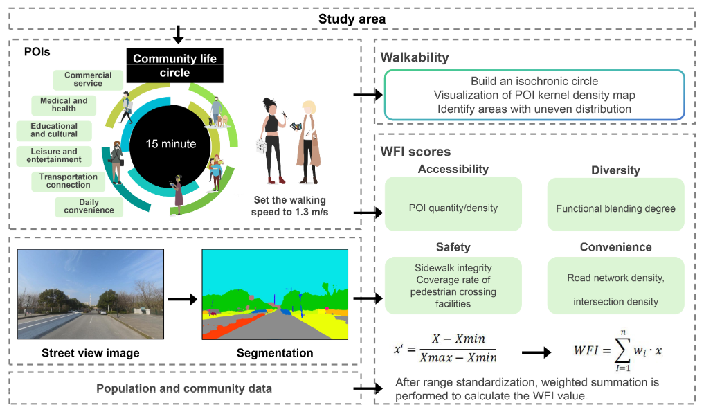
With industrial transformation and the rise in the 15 min community life circle, optimizing walkability and preserving industrial heritage are key to revitalizing former industrial areas. This study, focusing on Shijingshan District in Beijing, proposes a walkability evaluation framework integrating multi-source big data and street-level perception. Using Points of Interest (POI) classification, which refers to the categorization of key urban amenities, pedestrian network modeling, and street view image data, a Walkability Friendliness Index is developed across four dimensions: accessibility, convenience, diversity, and safety. POI data provide insights into the spatial distribution of essential services, while pedestrian network data, derived from OpenStreetMap, model the walkable road network. Street view image data, processed through semantic segmentation, are used to assess the quality and safety of pedestrian pathways. Results indicate that core communities exhibit higher Walkability Friendliness Index scores due to better connectivity and land use diversity, while older and newly developed areas face challenges such as street discontinuity and service gaps. Accordingly, targeted optimization strategies are proposed: enhancing accessibility by repairing fragmented alleys and improving network connectivity; promoting functional diversity through infill commercial and service facilities; upgrading lighting, greenery, and barrier-free infrastructure to ensure safety; and delineating priority zones and balanced enhancement zones for differentiated improvement. This study presents a replicable technical framework encompassing data acquisition, model evaluation, and strategy development for enhancing walkability, providing valuable insights for the revitalization of industrial districts worldwide. Future research will incorporate virtual reality and subjective user feedback to further enhance the adaptability of the model to dynamic spatiotemporal changes.
Evaluating and Optimizing Walkability in 15-Min Post-Industrial Community Life Circles
评估和优化15分钟后工业化社区生活界的步行性
1. Introduction and Literature Review/简介和文学评论
1.1. Transformation Challenges of Industrial Districts and Walkability/工业区和步行性的转型挑战
1.2. The “15-Min CLC” Concept and Walkability-Oriented Development/“ 15分钟CLC”概念和面向步行性的发展
1.3. Walkability Research Driven by Multi-Source Data/多源数据驱动的步行性研究
2. Data and Methods/数据和方法
2.1. Research Area and Analytical Framework/研究领域和分析框架
2.1.1. Study Area/研究区域
2.1.2. Analytical Framework/分析框架
2.2. Data Sources and Processing/数据源和处理
2.3. Walkability Evaluation Indicator System/步行性评估指标系统
2.4. Walkability Accessibility Analysis Method/可访问性分析方法
2.5. Calculation Method of Walkability Friendly Index/步行性友好指数的计算方法
3. Empirical Analysis: Measuring Community Walkability in Shijingshan District/经验分析:衡量Shijingshan区的社区步行性
3.1. Spatial Analysis of Walkable Accessibility/可步行可访问性的空间分析
3.2. WFI Results and Analysis/WFI结果和分析
3.3. Spatial Differentiation Patterns/空间分化模式
4. Discussion/讨论
4.1. Existing Problems in the Walking Environment/步行环境中的现有问题
4.2. Optimization Strategy Recommendations/优化策略建议
5. Conclusions/结论
研究内容
Research contents
本研究聚焦北京石景山区(曾为北方大型工业核心区,拥有首钢等企业,是中国工业遗产转型标杆),围绕后工业社区 15 分钟生活圈的步行性优化与工业遗产保护展开,核心内容包括:
核心问题:解决工业转型背景下,后工业社区步行性不足(如空间老化、功能单一、服务设施缺失、街道网络断裂等)与 15 分钟生活圈建设需求之间的矛盾,同时兼顾工业遗产活化与社区宜居性提升。
研究对象:选取石景山区 5 个典型社区(鸳鸯山水、五里春秋、老古城胡同区、荣景城、国际人才社区),覆盖高密度建成区、低密度生态区、未改造老旧区、新建高端社区、产业园区邻接社区等多种空间类型。
核心目标:构建适用于后工业社区的步行性评估框架,识别不同类型社区步行性差异及问题,提出针对性优化策略,为全球后工业区振兴提供可复制的技术路径。
This study focuses on Shijingshan District, Beijing (formerly a large industrial core area in the north, owns Shougang and other enterprises, and is a benchmark for the transformation of China's industrial heritage), and focuses on the walking optimization of the 15-minute living circle of the post-industrial community and the protection of industrial heritage.:
Core issues: (Solve the contradiction between the lack of walking nature of post-industrial communities (such as aging of space, single functions, lack of service facilities, broken street networks, etc.) and the construction needs of the 15-minute living circle under the background of industrial transformation, while taking into account the activation of industrial heritage and the improvement of community livability.
Research objects: Five typical communities in Shijingshan District (Yuanyang Mountains and Shui, Wuli Chunqiu, Laogucheng Hutong District, Rongjing City, International Talent Community) were selected, covering a variety of spatial types such as high-density built-up areas, low-density ecological areas, unrenovated old areas, newly built high-end communities, and industrial park neighboring communities.
Core objectives: build a pedestrian assessment framework suitable for post-industrial communities, identify pedestrian differences and problems in different types of communities, propose targeted optimization strategies, and provide replicable technical paths for the revitalization of post-industrial areas around the world. , providing a replicable technical path for the revitalization of post-industrial areas around the world.
研究方法
Research methods
1. 数据来源与处理
多源数据整合
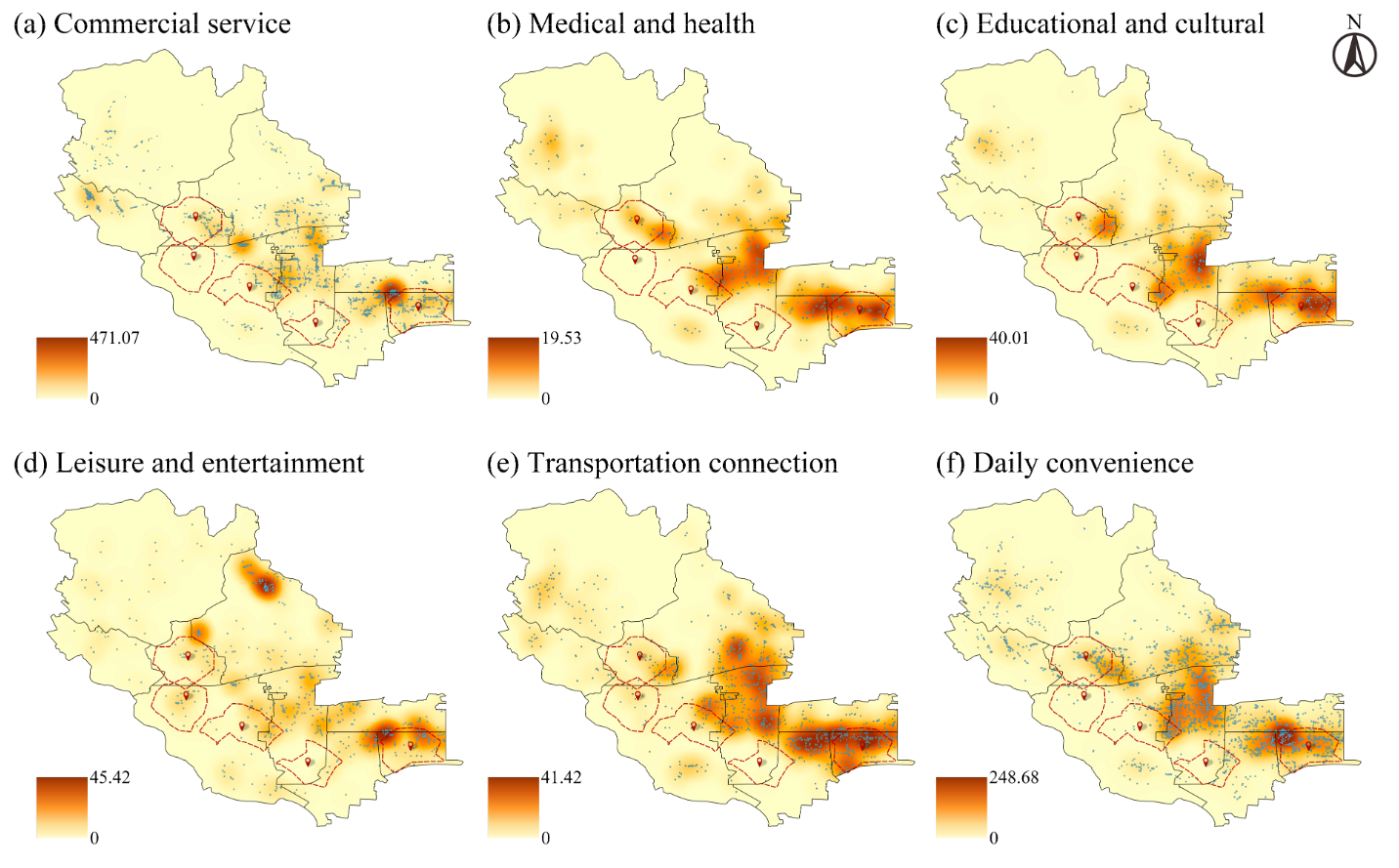
POI 数据:来自高德地图,经清洗、去重后按功能分为商业服务、医疗健康、教育文化等 6 大类,结合政府统计年鉴与实地调研验证,用于反映服务设施空间分布。
步行网络数据:基于 OpenStreetMap(OSM)提取,通过 OSMnx 库生成步行路网,用于计算路网密度、交叉口密度及构建 15 分钟生活圈空间范围。
街景图像数据:从百度街景采集,沿步行路网每 100 米设采样点,共获取 1114 张有效图像,通过语义分割技术提取人行道连续性、过街设施覆盖率等安全相关指标。
辅助数据:石景山区政府发布的人口、土地利用、行政边界数据,以及百度慧眼热力图提供的行人流量数据(用于模型验证)。
数据标准化:所有空间数据在 GIS 环境中统一投影与匹配,指标通过 min-max 归一化处理至 [0,1] 区间,确保可比性。
2. 评估框架与指标体系
四维评估维度:结合国际成熟框架(Walk Score、NEWS 等)与后工业社区特点,构建 “可达性、便利性、多样性、安全性” 四大维度,具体指标及权重如下表:
权重确定:采用层次分析法(AHP),邀请 10 位城市规划、交通工程等领域专家,通过 1-9 标度 pairwise 比较打分,经一致性检验(CR<0.1)后确定权重。
3. 关键分析方法
15 分钟生活圈构建:以各社区质心为起点,基于成人平均步行速度 1.3m/s(对应 15 分钟步行距离约 1170 米),采用 Dijkstra 最短路径算法,在 OSM 步行路网中划定生活圈空间范围。
1. Data source and processing
Multi-source data integration
POI data: From Gaode Map, after cleaning and deduplication, it is divided into six major categories including commercial services, medical health, education and culture
according to its functions. It is combined with government statistical yearbooks and field research verification, and is used to reflect the spatial distribution of service
facilities.
Walking network data: Based on OpenStreetMap (OSM), a pedestrian road network is generated through the OSMnx library, which is used to calculate road network
density, intersection density and construct a 15-minute living circle space range.
Street scene image data: collected from Baidu Street scene, sampling points were set up every 100 meters along the pedestrian road network, and a total of 1,114 valid
images were obtained. Safety-related indicators such as sidewalk continuity and crossing facilities coverage were extracted through semantic segmentation technology.
Auxiliary data: population, land use, administrative boundary data released by the Shijingshan District Government, as well as pedestrian flow data provided by Baidu
Huiyan Thermal Map (for model verification).
Data standardization: All spatial data are projected and matched in a GIS environment, and the indicators are normalized to the [0,1] interval through min-max to ensure
comparability.
2. Evaluation framework and indicator system
Four-dimensional evaluation dimensions: Combining the international mature framework (Walk Score, NEWS, etc.) and the characteristics of post-industrial communities,
we will build four dimensions of "accessibility, convenience, diversity, and security". The specific indicators and weights are as follows:
Weight determination: Analyzing hierarchy (AHP) was used, and 10 experts in the fields of urban planning, transportation engineering, etc. were invited to pass the 1-9
scale pairwise comparison and score, and the weight was determined after consistency test (CR<0.1).
3. Key analysis methods
15-minute living circle construction: Starting from the centroid of each community, based on the average walking speed of 1.3m/s for adults (corresponding to the
15-minute walking distance of about 1170 meters), the Dijkstra shortest path algorithm is used to define the living circle space range in the OSM pedestrian road network.
研究结果
Research conclusions
步行性差异:石景山区 5 社区 WFI 排名:远洋山水(0.7853,最优)>老古城(0.7063)>五里春秋(0.6161)>荣景城(0.3162)>国际人才社区(0.3010),呈 “中心 - 外围” 梯度。
核心问题:设施分布不均、路网断裂、安全设施不足、公共空间缺失。
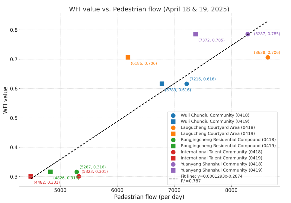
模型验证:WFI 与行人流量强正相关(r=0.887),模型可靠。
优化方向:修复路网、补建设施、升级安全配套,分区域差异化改造。Walking difference: 5 community WFI ranking of Shijingshan District: Yuanyang Mountains and Rivers (0.7853, optimal)>Old Ancient City (0.7063)>Wuli Spring and Autumn (0.6161)>Rongjing City (0.3162)>International Talent Community (0.3010), showing a "center-peripheral" gradient.
Core issues: uneven distribution of facilities, broken road network, insufficient safety facilities, and lack of public space.
Model verification: WFI is strongly positively correlated with pedestrian flow (r=0.887), and the model is reliable.
Optimization direction: repair road network, rebuild facilities, upgrade safety supporting facilities, and differentiated transformations in different regions.