A traffic-induced noise annoyance mapping method centered on the recipient (peeder) is proposed. Through psychoacoustic indicators, random forest modeling and open source data, expensive traffic flow statistics and proprietary software are avoided. Its five-step workflow (data collection, psychoacoustic value extraction, prediction modeling, test optimization, and propagation modeling) generates a high-resolution GIS noise annoyance map. The results show that the metropolitan scale annoyance mapping is technically feasible and economical, and can provide decision-making support for walking quality assessment, public space design and active transportation policy. It also points out that although this method has not been subjectively verified, it provides a new tool for urban health and noise pollution impact research.
研究内容
Research contents
本文聚焦于从行人视角构建交通诱导噪声烦恼的空间映射方法,核心是开发一种以接收者(行人)为中心、低成本且可复制的模型,替代传统以声源为导向的噪声评估方式。该方法利用心理声学指标(Psychoacoustic, PA)和开源数据,避免依赖昂贵的交通流量数据和专有软件,旨在为步行性规划、公共空间设计及主动交通政策提供决策支持,强调噪声对行人体验的影响而非单纯的物理排放。研究背景指出,现有噪声映射方法多关注静态居民区域,难以评估行人和移动车辆间的 “线源 - 线接收” 关系,而本文填补了这一空白,将噪声视为影响步行质量的关键指标。
This paper focuses on constructing a spatial mapping method for traffic-induced noise troubles from the pedestrian perspective. The core is to develop a low-cost and replicable model centered on the receiver (peedian), replacing the traditional sound source-oriented noise evaluation method. The method utilizes psychoacoustic indicators (PA) and open source data to avoid relying on expensive traffic flow data and proprietary software, aiming to provide decision-making support for pedestrian planning, public space design, and proactive traffic policy, emphasizing the impact of noise on pedestrian experience rather than simply physical emissions. The research background points out that existing noise mapping methods focus more on static residential areas, making it difficult to evaluate the "line source-line reception" relationship between pedestrians and mobile vehicles. This paper fills this gap and regards noise as a key indicator affecting walking quality.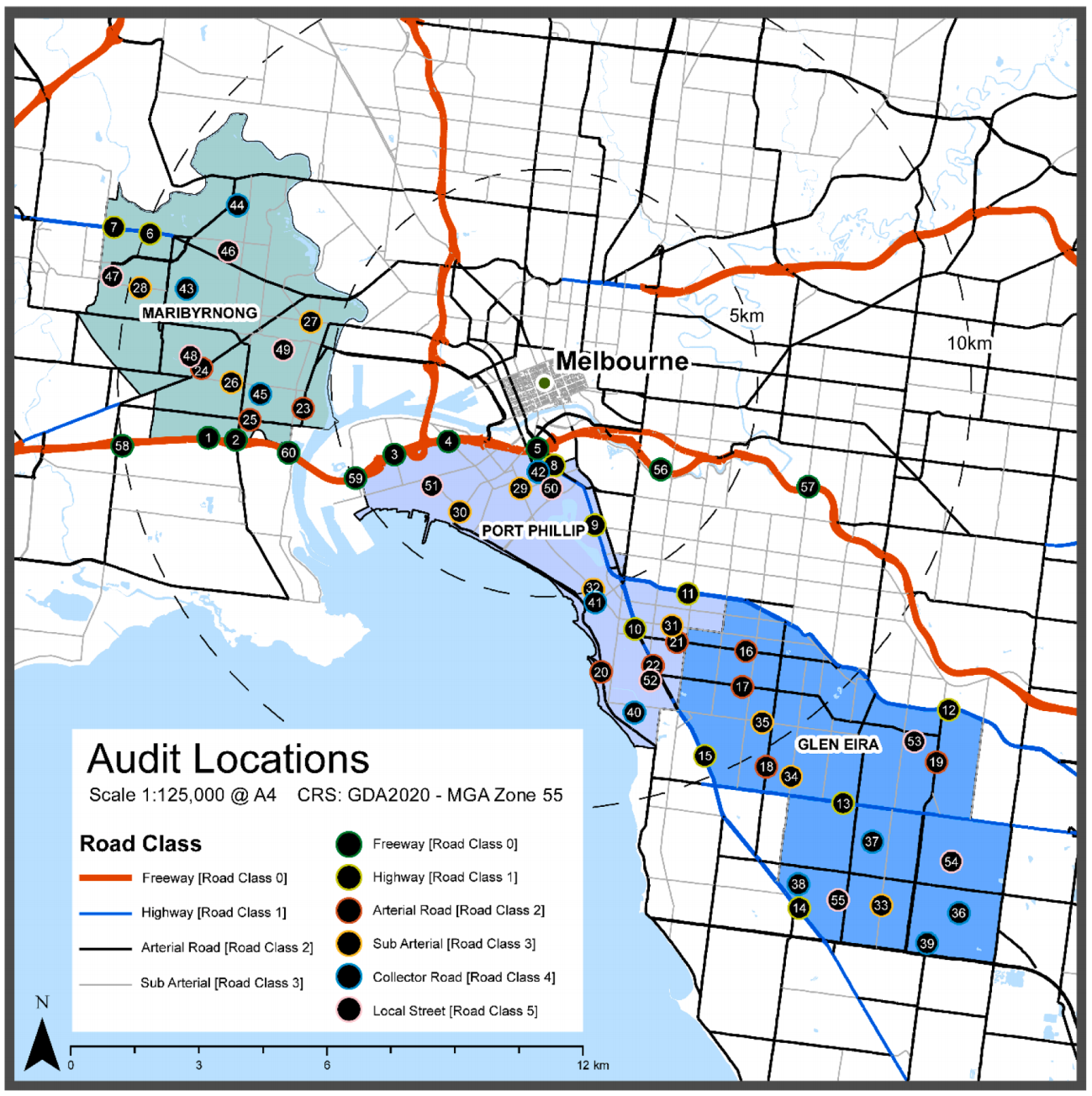
研究方法
Research methods
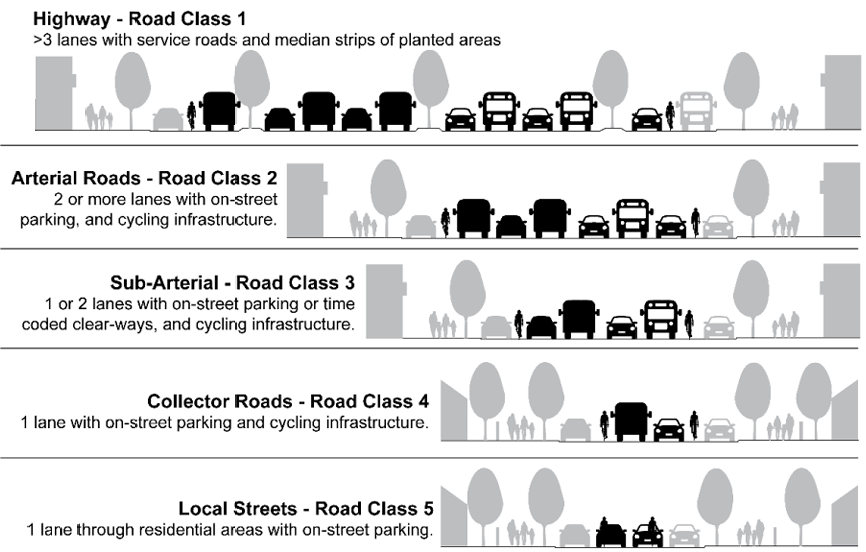
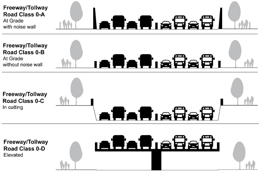
数据收集:包括 60 个地点的现场审计(覆盖白天、傍晚、夜间,记录交通噪声音频)、距离审计(4 个监测站,研究噪声随距离的衰减),以及从政府数据库获取的空间数据(如土地利用、道路等级、树密度等);
提取 PA 值:通过 MATLAB 音频工具箱处理音频样本,基于 Zwicker 和 Fastl 的心理声学模型计算 PA 值(整合响度、锐度、粗糙度等指标);
预测建模:使用随机森林(RF)回归模型,以 80% 数据训练、20% 数据测试, extrapolate 未审计区域的 PA 值;
测试与优化:通过调整超参数(如 mtry=5)提升模型精度,评估指标包括 RMSE(3.16)、MAE(2.38)等;
传播建模:应用指数衰减函数(PA×Exp (-0.0473× 距离)),在 GIS 中生成 1 米分辨率的噪声烦恼 raster 地图,覆盖道路两侧 40 米范围。
Data collection: includes on-site audits at 60 locations (covering day, evening, and night, recording traffic noise audio), distance audits (4 monitoring stations to study the attenuation of noise with distance), and spatial data obtained from government databases
(such as land use, road grade, tree density, etc.);
Extract PA values: The audio samples were processed through the MATLAB audio toolbox, and the PA values (integrated loudness, sharpness, roughness and other indicators) were calculated based on the psychoacoustic models of Zwicker and Fastl;
Predictive modeling: Using a random forest (RF) regression model, trained with 80% data, tested with 20% data, extrapolate the PA value of the unaudited area;
Testing and optimization: Improve model accuracy by adjusting hyperparameters (such as mtry=5). Evaluation indicators include RMSE (3.16), MAE (2.38), etc.;
Propagation modeling: Apply an exponential attenuation function (PA×Exp (-0.0473× Distance)) to generate a 1-meter resolution noise raster map in GIS, covering a range of 40 meters on both sides of the road.

研究结果
Research conclusions
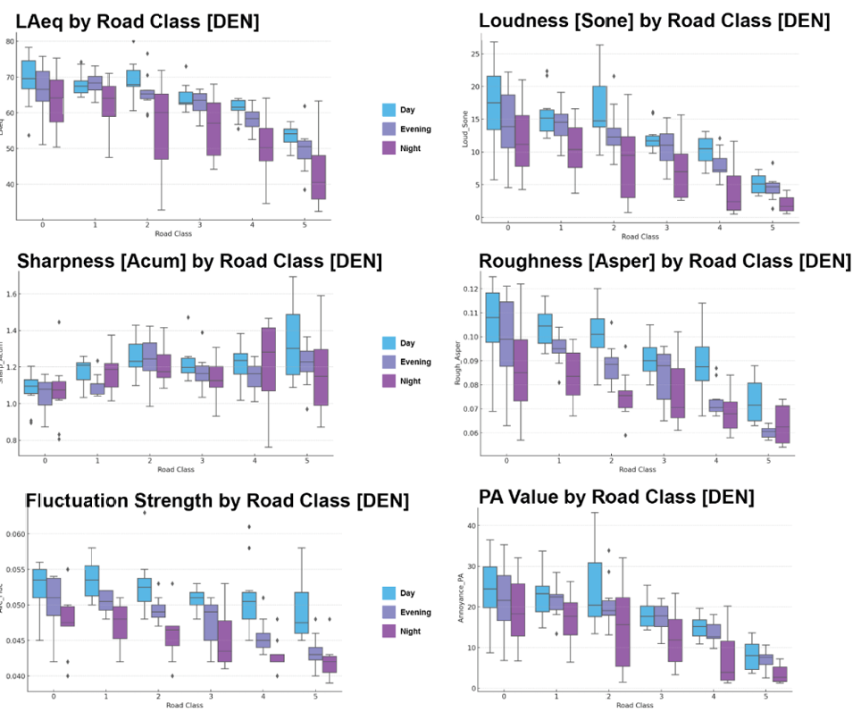
噪声特征:高速公路和主干道的噪声振幅全天较高,有隔音墙的区域振幅显著降低;噪声烦恼值白天最高,夜间最低,且随道路等级降低而递减;
模型性能:RF 模型预测能力强,训练集 R²=0.92,测试集 R² 通过 OOB 验证为 0.61,距离行人网络(Dist_pedne)是影响噪声烦恼的最关键因素,其次为土地利用类型和树密度;
空间映射:成功生成高分辨率噪声烦恼地图,可清晰显示不同区域的噪声影响强度,例如学校周边的噪声分布,为针对性干预(如交通 calming、绿化)提供空间参考。
Noise characteristics: The noise amplitude of highways and main roads is higher throughout the day, and the amplitude of the area with sound insulation walls is significantly reduced; the noise annoyance value is the highest during the day and the lowest at
night,and decreases with the decrease in road grade;
Model performance: The RF model has strong predictive capability, training set R²=0.92, and test set R² is verified to 0.61 by OOB. Distance pedestrian network (Dist_pedne) is the most critical factor affecting noise annoyance, followed by land use type and tree
density;
Spatial mapping: Successfully generated a high-resolution noise trouble map, which can clearly display the intensity of noise impact in different areas, such as the noise distribution around the school, and provide spatial reference for targeted interventions (such
as traffic calming, greening).